tectonic aneurysm model
Here are some more details about our model for how fierce erosion can influence crustal evolution at a local scale. In case you're wondering, our computer models show that the basic physics and mechanics are robust and straightforward (see the paper by Koons et al. in 'Publications'). What's less clear are some of the consequences, in particular whether true feedbacks between erosion and mechanics come into play.
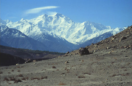
Figure 1. Nanga Parbat seen from the north. The relief that's visible from the massif's summit to its base is over 7,000 meters (23,000 feet).
Introduction
Technically, an aneurysm is the pathological expansion of a blood vessel. How we've come to apply this term to the geology of parts of the Himalaya will, we'd wager, require a little explanation. For the moment, consider what is involved in the development of an aneurysm (you might find it more useful to think of what happens when you try and blow up a balloon). Somewhere along a normally strong surface, either a true weakness develops or there is an area that in a relative sense is weaker than its surroundings. Under applied stress, failure is most likely to occur in this weaker area. Once failure begins, the area becomes even weaker, thus concentrating deformation and leading to a ballooning as the boundary thins even more. Positive feedback is possible in this process, because increasing deformation further weakens the deforming region, and this in turn localizes and enhances the deformation.
To show you how we think this type of general phenomenon might be at work at the ends of the Himalayan chain, we need to discuss a few points related to the strength of rocks, the distribution and flow of heat in the Earth, and the geology of the Himalayan corners.
Crustal Strength
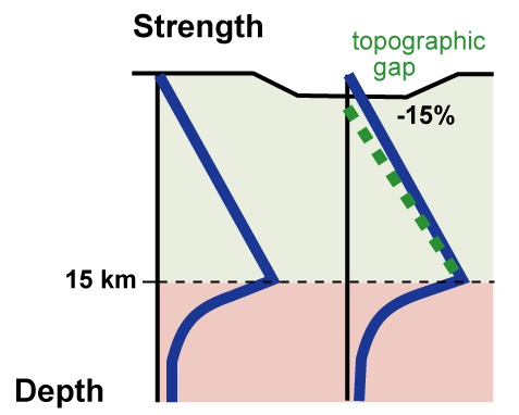
Figure 2. Crustal stength profiles for standard conditions, and for a large topographic gap.
It's generally accepted that the strength of the crustal part of the lithosphere is not uniform. The first of the two curves at left (Figure 2) gives a general representation of the strength of crustal rocks as a function of depth. In the shallower crust, which deforms in a brittle fashion, strength is pressure-dependent, and increases linearly with depth. However, as temperatures rise, rock strength begins to fall exponentially as the rock's constituent minerals become capable of solid-state flow. The mechanisms responsible for this are a strong non-linear function of temperature. There comes a zone in the crust where deformation mechanisms change from brittle to ductile and the increasing ductility dominates. This is shown schematically on the plot as the single high-strength cusp in the strength profile. The exact nature of this zone will depend on rock type, deformation rates, and the temperature distribution; crudely one could say that the transition occurs over the temperature range 300 to 400 C.
If a topographic gap is cut into the crust (Figure 2-right), one immediate result is that the crust right below the gap will be somewhat weaker than crust on either side, ignoring any thermal effects associated with the cutting of the gap. In addition (not shown on Figure 2), rocks along the steep slopes on the valley flanks will end up closer to failure as well, due to the distribution of stresses around the topography. If the region containing the gap is experiencing regional stress at the appropriate orientation, these effects alone could be enough to lead to failure in the form of faulting in or along the valley. As a rough rule of thumb, this effect could become important if the valley width approaches the thickness of the upper brittle layer in the crust, so we're talking valleys that are 10-20 km across between their slopes, and several kilometers deep.
Thermal Effects of Topography and Rapid Erosion

Figure 3. Isotherms near a large valley.
The cutting of a big, deep valley can lead to two main impacts on the distribution of crustal temperatures. First, the thermal gradient beneath a valley will be steeper because of the way isotherms respond to the shape of the surface. The temperature distribution in the crust is what physicists would call a potential field, and at a distance potential fields tend to feel only the average of remote boundaries. Isotherms in the mid and lower crust will not respond much to the valley's shape (Figure 3). Second, if cutting of the gap weakens the local crust sufficiently (see above), faulting may occur in the valley, carrying rocks towards the surface. At high rates of motion of a millimeter per year or more, rocks will actually carry heat with them faster than this heat can be lost by diffusion (more...). This has the effect of steeping the temperature gradient in the affected region, warming the shallow crust.
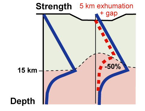
Figure 4. Crustal stength profile for rapid advection and erosion in a large topographic gap.
Figure 3 shows the dramatic effect that valley cutting and subsequent failure can have on the local geotherm and local rock strength. The curve at left is the schematic reference for stable crust, and the curve at right shows the combined effects of both physical gap-cutting plus the thermal reponse to topography and erosion at a few millimeters per year. It is easy to get strength reductions on the order of 50% under such conditions. In effect, the crustal strength profile is being "eroded" from below as hot, weak rocks replace colder ones. Such dramatic strength reductions will tend to localize strain and divert flow of crust into the high-strain region.
Nanga Parbat Geological Setting
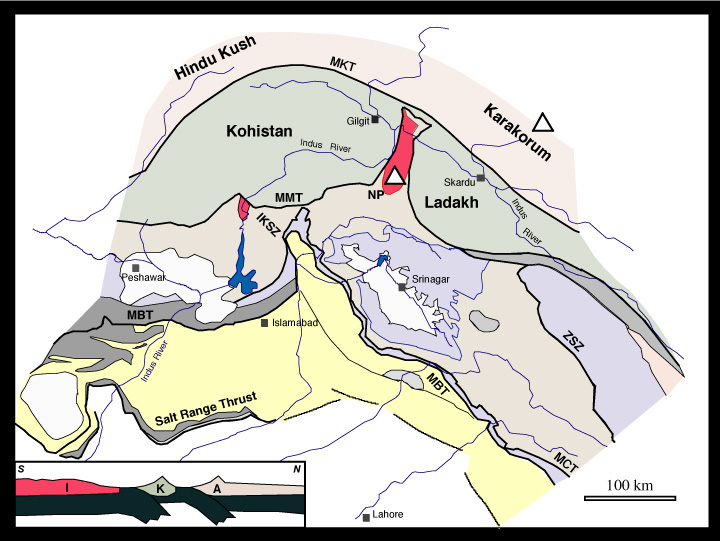
Figure 4. Tectonic overview of the NW Himalaya (enlarge (120 KB)).
Located at the core of the NW Himalayan synataxis (Figure 4), Nanga Parbat and related peaks like Haramosh define a dramatic topographic massif (Figure 1). There are a number of geological and geophysical feature within Nanga Parbat that serve to define it as a "metamorphic massif" as well (a structurally coherent exposure of high-grade gneisses) (Figure 5). Active and young faults around the Nanga Parbat-Haramosh Massif expose old Indian-plate gneisses 500 Ma and 1850 Ma in age, but these gneisses have undergone and are undergoing an episode of reworking; by this we mean pervasive deformation, young metamorphism and melting, widespread fluid flow, rapid and pronounced exhumation by erosion (not normal faulting), and sculpting of the crust into spectacular, steep topography. Within the core of the massif, there is a bull's-eye coincidence between the massifÕs most extreme topography and high-temperature granulite-grade migmatites, a young and active antiformal pop-up structure, young 1-2 Ma granitoids, abundant seismicity with sharp bottom and lateral cut-offs, pronounced hydrothermal activity, steep near-surface thermal gradients, and rapid denudation documented across a wide range of timescales.
Several lines of evidence that apply over a great range of time scales all converge on an exhumation rate of about 4-5 mm/yr for Nanga Parbat over the past 3 million years. These estimates include direct, short-term measurements of sediment flux, fluid-inclusion measurements to determine P-T conditions together with biotite dating, and metamorphic pressure-temperature estimates together with U-Pb zircon dating.
Here are some figures that summarize these data (click on the thumbnails to open them). Beware: a few are quite large.
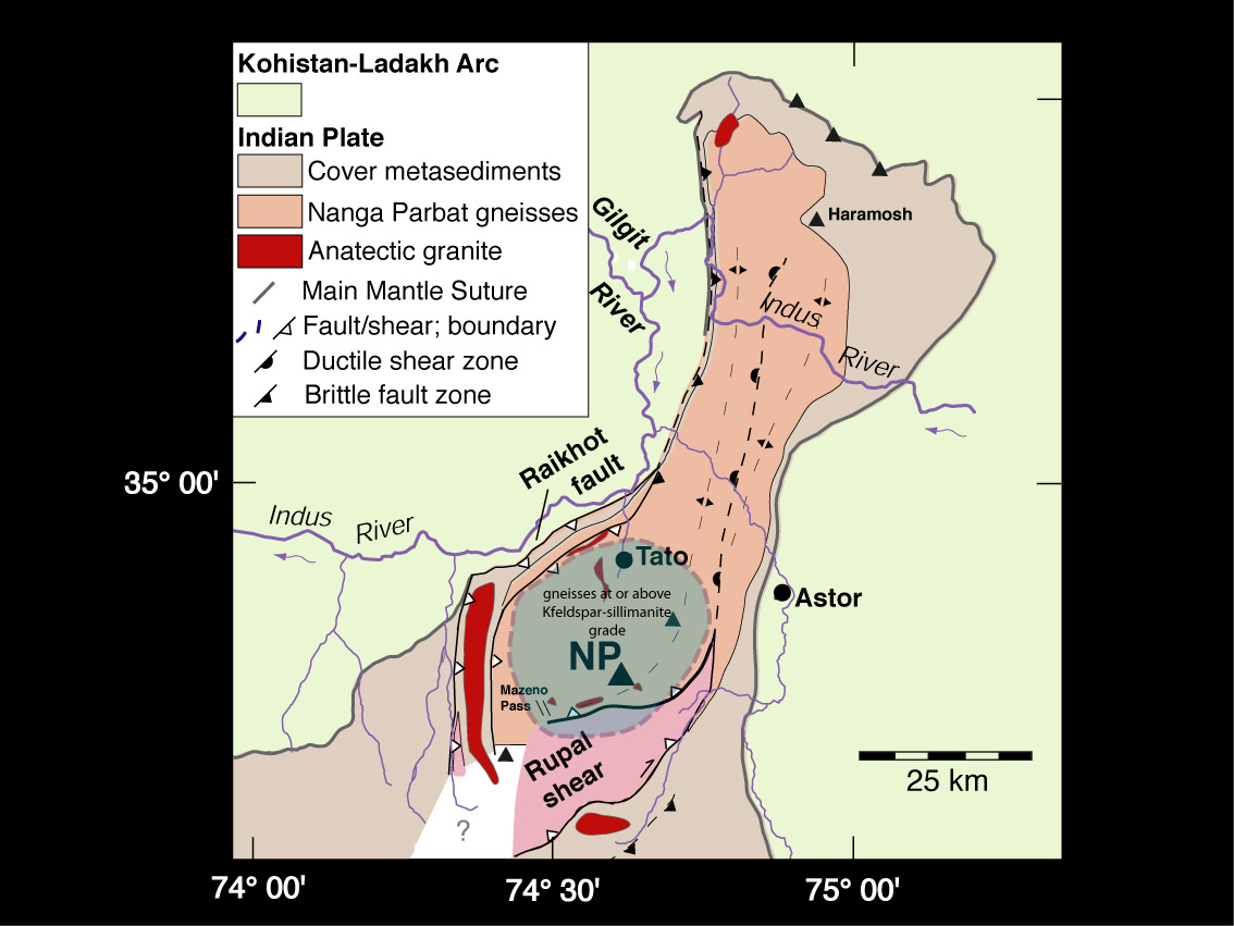
Figure 5. Simplified NP geological map. (180 KB) |
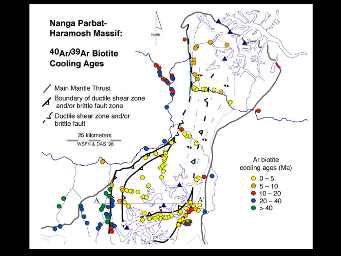
Figure 6. Ar-Ar cooling ages on biotite. (76 KB) |
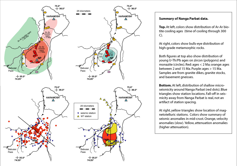
Figure 7. Summary of geological and geophysical data, map view. (128 KB) |

Figure 8. Summary of geophysical data, in section. (144 KB) |
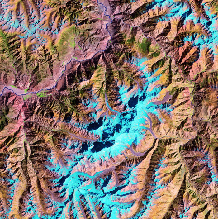
Figure 9. Thematic mapper image of NP (center), Indus River (upper left) and Gumugah surface (uppermost left). (276 KB) |

Figure 9, large (1.9 MB) |
The Model
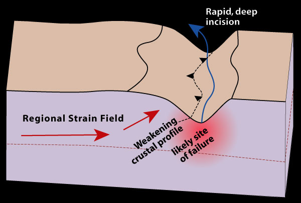
Figure 10. Early stages in development of a tectonic aneurysm. Failure into region near valley is likely due to stress distribution around steep slopes, and steepened thermal gradient beneath valley.
Probably the first thing we should note about the aneurysm model is that its name, while colorful, is jargon. More properly, we should say that the model involves erosional, thermal, and mechanical coupling. Hmmm. That's not much better.
But it is descriptive of the key elements in the model. What we're proposing is that a warm crust that is being subjected to orogenic stresses will fail at its weakest points, and one such point can be provided by a deep topographic divot like a big river valley, for both thermal and mechanical reasons (Figure 10). If such failure occurs, this can be amplified by feedbacks involving advection of hot rock, due to thermal thinning of the strong upper layer in the crust. This will in turn further localize and enhance deformation as regional strain is diverted into the weakening zone.
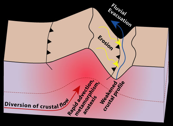
Figure 11. Fully developed stage of a tectonic aneurysm.
As this process proceeds, the rapid rock uplift will lead to development of a big mountain as the thermal weakening becomes dominant over the gap effect, such that the strain will be diverted into the mountain massif, with the river serving to scour away erosional products from the growing topography (Figure 11). The rapid erosion required to keep the system going is provided by both the high topography and the downcutting river, and the diversion of strain and advection of hot rock comes courtesy of the mechanics of the system. Hence, the system involves thermal, erosion, and mechanical components, all of them linked to one another.
The geological consequences of this process are many. The diversion of strain into the growing massif will show up as a fairly localized doming associated with active compressional faulting. The rapid rock uplift will strongly perturb the geotherm, causing rocks entering the massif to be turned upward and rapidly decompressed under nearly isothermal (constant-temperature) conditions. This can lead to small degrees of partial melting and high-temperature/low-pressure decompression metamorphism. Towards the surface, vigorous fluid-flow systems will develop above the very steep temperature gradients in the shallow crust. All of these processes wil lead to setting or resetting of most dating systems, and development of structures and metamorphism that overprint older signatures. All of these are the kind of phenomena that we see at Nanga Parbat.
Implications, Speculations, Applications
Let's assume for the moment that this model holds. What are its implications for the study of mountain belts, and how might it apply to the geological record?
Most directly, the aneurysm model underscores the important role that the surface can play as a boundary condition for tectonics, and the important part that surface processes like erosion can play in geodynamics. In this view, erosion is an active player, not just a passive result of uplift. Further, events at Nanga Parbat are only indirectly correlated in time in space to the overall India-Asia collision. Although the massif developed as a consequence of this collision, its evolution is separated by some 50 to 60 million years from the time of collision, and clearly the influence that river-carved topography played is not predictable from plate-scale theory nor from structural models.
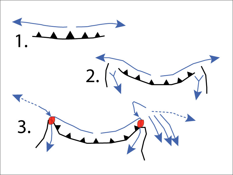
Figure 12. Evolution of major drainges in a growing orogen. As the orogen develops (1), rivers on the upthrust block flow parallel to the main range. With onset of full collision and indentation of one block into the other, indentor corners and syntaxes develop (2), capturing upslope precipitation and fostering headward cutting into the elevated uplands. Finally, headward cutting leads to capture and diversion of main drainages, cutting of deep gorges, and, if the aneurysm model holds, development of metamorphic massifs in the core of the syntaxes.
Or is it? As Peter Koons has pointed out, the structural grain and topographic trends that are established as a collisional mountain belt grows must organize the overall flow patterns of rivers draining the orogen. Rivers on the higher-elevation "back" of the orogen (e.g., like the Indus and Tsang Po in Tibet) will be forced to drain laterally because they cannot get across the growing main range. The point where they escape to the foothills may not be a function of chance.
We've theorized that the hyperactive metamorphic massifs in the Himalaya are in the indentor corners because that is where the big rivers are. Well, the big rivers may be there, exiting through the corners, because the corners are a likely place for such rivers to be captured and diverted to the foothills (Figure 12). The syntaxes are zones of vigorous headward (upstream) erosion, as they are funnels that collect and focus precipitation that impinges on their steep slopes, and of course the steep slopes themselves lead to high erosion rates. So there may be a link after all between plate scale dynamics which cause the development of indentor corners and syntaxes, the diversion of rivers into the syntaxes, and the development of metamorphic massifs near the deep gorges cut by the rivers as they exit the mountains. All very interesting: all we need to do is prove it.
Does the aneurysm model have legs when it comes to looking at the geological record? On the one hand, it's quite possible to imagine that dynamic and prominent as Nanga Parbat is today, little will survive tens of kilometers of erosion once the Himalayan orogeny shuts down and is worn away. Certainly none of the topography nor any direct evidence for a large river will be preserved, and given our model in which crust flows in laterally and is diverted upward, deep enough erosion will expunge all but the most cryptic, deep-seated evidence that there was once a metamorphic massif at the site. On the other hand, gneiss domes are abundant in the geologic record, and it is interesting to speculate whether some of these might in part be the products of vigorous local erosion by rivers now long gone.
Where next? One problem with geological models involving feedbacks is the difficulty in documenting them with geological data, as you need to have detailed evidence for how one particular process or condition preconditioned the next, and in turn was itself influenced by the result. Generally, Nature deals you the hand you've got, and even with the most state-of-the-art techniques and lots of hard, careful work, direct evidence is hard to come by. We're currently looking at the Namche Barwa massif in southeastern Tibet as a second case study to which which we can apply the notion of feedbacks between erosion and mechanics. It's got a tectonic setting that's broadly similar but different in detail, plus a big river that flows right across it.