Significance and Background
Geodynamic Setting of Central Mongolia and the Hangay
Western Mongolia and adjacent parts of central Asia currently accommodate ~10 mm/yr of northward-directed shortening related to the India-Asia collision. The Hangay Mountains occur in a kinematic transition between predominantly compressional deformation to the south and extensional deformation to the north. The northern margin of the plateau and adjacent parts of the Siberian Craton are dominated by the active Baikal and Hovsgol intracontinental rifts.
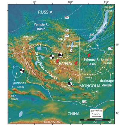
Physiographic map of western Mongolia. Thin black lines—major faults. Heavy white dashed line—present drainage divide between internally-drained rivers and rivers of the Selenga basin flowing to the Arctic. Fish symbols—representative sampling locations (see In Depth Disciplinary secitons). White arrows—GPS velocities and 95% confidence ellipses with respect to stable Europe. Short dashed white line—estimated lithospheric thickness in km. Focal mechanisms show 20th century earthquakes with M >8.
Situated in this complex juncture between regions of active shortening and extension, the Hangay Mountains and trans-Hovsgol ranges occupy a broad domal upland (~425,000 km2) containing the embedded Hangay Dome, (~200,000 km2) a largely intact block-uplift, flanked by major, currently active strike-slip faults. The high interior of the dome sits at elevations ~1.5 km above the regional trend and locally reaches elevations of up to 4000 m. To the southwest, the internally drained Mongolia Depression of Lakes and Valley of Lakes lie between the Hangay uplift and the Altai ranges.
The high topography of the Mongolian Plateau and Hangay Dome has been variably attributed to far-field effects of India-Asia convergence, Pacific plate subduction, propagation of rifting southward from Lake Baikal, isolated mantle-plume activity, lateral mantle flow and upwelling at the southern edge of the Siberian Craton, lithospheric delamination, and/or the presence of underplated magmatic rocks at the base of the crust.
